
Why You Need a Land Survey Before Starting Any Construction Project in Nigeria
In Nigeria’s property market, where disputes over land boundaries, ownership, and government acquisition are common, a land survey is one of the smartest steps you can take before starting any construction. It is the legal and technical process of determining the exact boundaries, measurements, and features of a piece of land.
The professional responsible for this is a land surveyor, licensed by the state surveyor-general’s office and regulated by the Surveyors Council of Nigeria (SURCON).
A proper land survey does more than just mark the edges of your property—it protects your investment, ensures compliance with government regulations, and provides the data your engineers and architects need to design a safe, efficient project.
What is a Land Survey?
A land survey is the process of measuring and mapping land to determine its boundaries, shape, size, and features. In Nigeria, it is usually tied to the national grid system so that every plot has precise coordinates.
Surveys may also include information about the land’s topography (slope, elevation, drainage), ownership, and restrictions, all of which are critical before building begins.
10 Importance of Land Surveying
- Confirms the Actual Boundaries of Your Land, Prevents you from mistakenly building outside your property line.
- Prevents Land Encroachment Issues, by protecting you against neighbours claiming part of your property.
- Required for Government Approvals, Most state physical planning offices will not issue a building permit without a survey plan.
- Identifies Topography and Site Conditions, Reveals natural features like slopes, streams, or depressions that affect construction.
- Protects Your Investment, Prevents costly errors such as building on the wrong plot or in a government acquisition zone.
- Helps in Land Valuation and Resale, Buyers and banks trust surveyed properties more, making sales or mortgages easier.
- Guides Future Development Plans, Makes it easy to plan extensions or subdivide the property later.
- Avoids Costly Legal Disputes, Provides legal evidence in boundary-related court cases.
- Supports Land Registration, Essential for obtaining a Certificate of Occupancy (C of O).
- Boosts Buyer Confidence, A surveyed property commands more trust and higher value.
Land Survey Documents You Need in Nigeria
When you hire a land surveyor, the primary document you receive is a Survey Plan, a legal drawing that represents your land on paper.
A Survey Plan Includes:
- The plot diagram shows dimensions
- North point direction for orientation
- Coordinates tied to the national grid
- Boundary beacons or pillars
- Description of the land and use (e.g., residential, commercial)
- Name of the owner
- Surveyor’s name, signature, and seal
- Date of survey
Plan Shewing Property – Meaning:
This is simply the diagram within the survey plan that shows the property boundaries and surrounding plots. It is the visual proof of where your land lies.
Sample of a Survey Plan in Nigeria
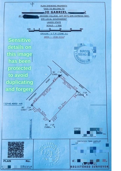
In Nigeria, a typical survey plan might look like:
- A scaled drawing of the property with coordinates
- Beacons labelled (e.g., BP1, BP2, BP3, BP4)
- Reference to the Lagos State or Federal Survey Control
- Notes on restrictions (e.g., “free from government acquisition”)
- Official seal of the licensed surveyor
Example:
A plot in Abuja may show precise coordinates that align with FCT mapping records, ensuring it does not overlap a road reserve or drainage path.
Types of Land Survey in Nigeria
- Cadastral Survey – Establishes property boundaries for ownership and registration.
- Topographic Survey – Shows natural and man-made features plus elevation.
- Engineering Survey – Supports the construction of roads, bridges, and infrastructure.
- Hydrographic Survey – Maps rivers, lakes, and coastal areas.
- As-Built Survey – Verifies completed structures against original plans.
Land Survey in Nigeria & Why It’s Non-Negotiable
From Lagos to Port Harcourt, Abuja to Kano, the value of land keeps rising, and so do disputes. Without a survey, you risk:
- Losing part or all of your property in a dispute
- Facing demolition due to encroachment
- Being denied a building permit
- Constructing in flood-prone or unstable areas
A land survey is your first line of defense against any land risks
Getting a land survey before construction is not just a formality; it is a legal, technical, and financial safeguard.